Google Maps has validated what many Bengaluru residents have long suspected: walking can sometimes be faster than driving in the Silicon Valley of India. Daily commuters lose hours in productivity due to the city's notorious traffic jams. As Bengaluru evolved into India's IT capital, it attracted thousands of professionals, but its infrastructure has struggled to keep up with the influx. Factors such as rapid urbanization, poor planning, and limited public transport options contribute to the city's congested roads and peak-hour traffic.
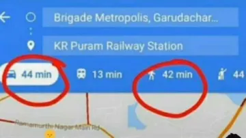
Yesterday, X user Ayush Singh shared a Google Maps screenshot comparing the time needed to walk versus drive from Brigade Metropolis to KR Puram Railway Station, covering a distance of about 6 km. According to his screenshot, driving between the two locations would take 44 minutes, whereas walking would be slightly quicker at 42 minutes, contrary to expectations.
Singh shared the screenshot on X with the caption, “This happens only in Bangalore.”
Take a look at the post:
His post is quickly going viral, amassing over 300,000 views in just one day on the microblogging platform. While many people concurred that Bengaluru’s traffic can be exhausting, others challenged his “only in Bengaluru” perspective.
One user wrote, “Same story across many metro cities in the world.” Another user commented, “Mumbai and Delhi also have the same situation during peak.” One individual referred to Bengaluru as the "Traffic Capital of India," while others suggested that Singh use public transportation to steer clear of congested roads.
Yesterday, a CEO from Bengaluru proposed a new way to handle the city's traffic issues. Paras Chopra took inspiration from a system used in Beijing, where drivers stuck in traffic can call for a ‘rescue’ service for $60. In this service, a motorbike rider picks up the stranded commuter, while another person drives their car to its destination.
ALSO READ: Record-breaking rainfall hits Pune, internet flooded with alarming images of the city
