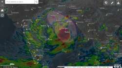
Esri India's new GIS Map to provide insights on Cyclone Yaas
Geographic Information System (GIS) Software and Solutions provider Esri India on Tuesday created a map to follow the live path of the cyclone Yass in the Bay of Bengal.

Geographic Information System (GIS) Software and Solutions provider Esri India on Tuesday created a map to follow the live path of the cyclone Yass in the Bay of Bengal.
The map is built with ArcGIS Online, Esri's mapping and analytics system, and provides updates on the weather, wind speed, number of households and population in the area. The map is consolidating the information from various authoritative feeds and sources for an integrated view on the movement and impact of Cyclone Yass.
The Cyclone Yass Live Path GIS Map application would also help in early preparedness in terms of most affected areas, evacuation planning, shelters, and rehabilitation plans so that there is timely action for the safety of life and property.
"The Cyclone Yass Live Path Map is specifically created to provide updates leveraging GIS technology. This will help citizens and organisations involved to prepare and temporarily re-locate to lesser severe areas. At Esri India, our focus is to bring information together from different sources and share in a common GIS platform so that it can help reduce damages and facilitate a collaborative response in saving lives and property," said Agendra Kumar, Managing Director, Esri India, in a statement.
The cyclone in Bay of Bengal laid centred at 5.30 a.m. on Monday near latitude 16.3 degree north and longitude 89.7 degree east, about 600 km north-northwest of Port Blair (Andaman Islands), 540 km south-southeast of Paradip (Odisha), 650 km south-southeast of Balasore (Odisha) and 630 km south-southeast of Digha (West Bengal).
It is very likely to move slowly north-northwestwards, intensify further into a Severe Cyclonic Storm during next 24 hours and into a Very Severe Cyclonic Storm during subsequent 24 hours, said National Weather Forecasting Centre of the India Meteorological Department.
