NASA to launch laser-armed satellite into space next month to study Earth's changing ice sheets
The mission, called the Ice, Cloud and Land Elevation Satellite (ICESat-2), is scheduled to launch in September.

NASA is all set to launch a laser-armed satellite that will spend three years studying Earth's changing ice sheets.
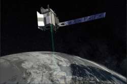
The mission, called the Ice, Cloud and Land Elevation Satellite (ICESat-2), is scheduled to launch in September. The satellite will be able to measure the changing thickness of individual patches of ice from season to season, registering increases and decreases as small as a fifth of an inch.
"The areas that we're talking about are vast — think the size of the continental U.S. or larger — and the changes that are occurring over them can be very small," Tom Wagner, a NASA scientist studying the world's ice, said during a news conference last week.
The mission will also aid scientists studying forests around the planet.
NASA has excelled at measuring the area ice covers for decades now, watching ice sheets shrink and grow in two dimensions as the seasons change and the planet warms.
Speaking on the new mission, Tom Neumann, NASA's ICESat-2 deputy project scientist said that the satellite is a revolutionary new tool for both ice and sea ice research.
ICESat-2 will orbit about 300 miles (500 kilometers) above Earth's surface carrying an instrument called the Advanced Topographic Laser Altimeter System (ATLAS). The instrument will constantly emit a laser beam of green light, which will be split into six separate beams as it leaves the satellite. The beams will then bounce off the surface of the ice in a grid pattern. Most of the photons in the laser beams will be lost in scattering, but a handful will make their way back to the satellite.
Once the spacecraft begins its observations, scientists will have access to a wealth of new data about the Earth's ice sheets and how they are changing over time.