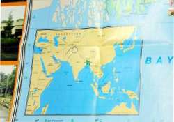
UN official uses wrong India map; parts of J&K missing
New Delhi: An incorrect map of Jammu and Kashmir was presented by a top UN official today at a water summit here to discuss the sanitation situation in India. The territory of India bordering Pakistan

New Delhi: An incorrect map of Jammu and Kashmir was presented by a top UN official today at a water summit here to discuss the sanitation situation in India.
The territory of India bordering Pakistan and China in Jammu and Kashmir was not part of the map shown by Sue Coates, chief of WASH UNICEF India, to tell the proportion of population defecating in open in the country. When contacted, a UN official said, “it was not at all intentional”.
Later, Caroline den Dulk Chief Communication, UNICEF India, told PTI in an e-mail, “The map used for the purpose if from an article used by another organisation and is certainly not to-scale.
Therefore it may have appeared to you that the state of J&K is incorrectly displayed which was not at all our focus or purpose.”
Coates made the presentation at the opening session of the ‘India Wash Summit' organised by the WaterAid, a global NGO working to transform lives by improving access to safe water, improved hygiene and sanitation in the world's poorest communities.
The panelists of the opening session included bureaucrats, social activists, academicians and bank representatives.
They discussed some of the opportunities and challenges in the water, sanitation and hygiene sector in India, focusing on Prime Minister Narendra Modi's ambitious Swachh Bharat Mission.
Coates completed the presentation just few minutes ahead of arrival of Rural Development Minister Chaudhary Birender Singh.
Singh launched the three-day ‘India Wash Summit' along with many dignitaries including Coates by floating diyas in a vessel filled with water.