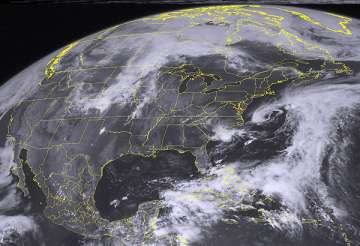
Raleigh (North Carolina), May 20: Tropical Storm Alberto swirled off the South Carolina coast packing maximum sustained winds of 50 mph (85 kph) on Sunday, a day after becoming the first tropical storm of the 2012 hurricane season, the National Hurricane Center said.
The Miami-based center said Alberto was centered about 105 miles (170 kms) southeast of Charleston, S.C., at 2 a.m. EDT (0600 GMT) and moving toward the southwest near 6 mph (9 kph). It added that a tropical storm watch continued for South Carolina from the Savannah River to the South Santee River.
Forecasters have advised coastal interests from Georgia to North Carolina's Outer Banks to track the storm, citing the potential for dangerous surf.
The hurricane center issued its initial tropical storm watch for Albert on Saturday once the storm formed in the Atlantic. The official start to hurricane season is June 1, but tropical storms occasionally occur before then.
National Weather Service meteorologist Sandy LaCorte in Wilmington said projections on Saturday evening showed the storm was expected to turn to the northeast over the next several days.
She said the center of the storm was not expected to get close to the Carolinas' coast, though forecasters said dangerous surf conditions were possible along both the South Carolina and Georgia coasts. The storm also was about 145 miles (235 kilometers) east of Savannah, Georgia., early Sunday.
LaCorte said Alberto was expected produce increased waves at beaches in the Carolinas. There also is a high risk of rip currents along North Carolina's Outer Banks, and a moderate risk along the southeastern beaches and the entire South Carolina coast.
The weather service also said isolated and scattered rain showers are expected along the coast of the Carolinas over coming days.
A forecast map by the hurricane center predicts that the storm would drift toward the open sea off the Mid-Atlantic region by midweek, but it's difficult to accurately predict a storm's path days in advance.
The 2 a.m. EDT Sunday advisory said Alberto, meanwhile, was expected to turn toward the west-northwest later in the day and then head to the north and northeast sometime Monday.
Little change in strength was forecast over the coming 48 hours, the center added, noting the maximum sustained winds were at 50 mph (85 kmph) with higher gusts.
Forecasters added that tropical storm force winds extended about 45 miles (75 km) out from the center of Alberto.
Latest World News
