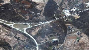
A Russian military convoy threatening Kyiv is far bigger than initially thought, with satellite images showing it occupying much of a 40-mile (64-kilometer) stretch of road north of the Ukrainian capital. Today (Tuesday) is the sixth day of the Russian military assault on Ukraine.
The vast convoy of armoured vehicles, tanks, artillery and support vehicles was 17 miles (25 kilometers) from the centre of Kyiv and stretched for about 40 miles, according to satellite imagery from Maxar Technologies.
The Maxar photos also showed deployments of ground forces and ground attack helicopter units in southern Belarus.
Satellite photo of Russian forces approaching Kyiv
Maxar said the newer images cover a wider area and were less obscured by clouds. Several homes and other buildings were seen burning near roads where the convoy is travelling.
Russian troops have been advancing slowly on the capital city of nearly 3 million people. But its invasion has met unexpectedly stiff resistance. The troops have slowed Russia's advance and held onto the capital and other key cities. As talks between Ukrainian and Russian delegations wrapped up near the Belarusian border on Monday, several blasts were heard in Kyiv.
Satellite photo of Russian forces approaching Kyiv
According to the US officials, they believe the invasion has been more difficult than the Kremlin envisioned, though that could change as Moscow adapts. Russia still lacked control of Ukrainian airspace.
READ MORE: India reiterates call for immediate cessation of violence, end to hostilities
READ MORE: Russia launches attack on Kyiv soon after talks with Ukraine end | WATCH
Latest World News

