3 reasons why Haiti saw massive devastation in powerful earthquake
The reasons are a combination of factors, including a seismically active area, a high population density of 11 million people and buildings that are often designed to withstand hurricanes -- not earthquakes.

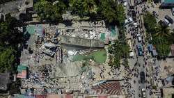
A powerful earthquake over the weekend has killed more than 2,100 people in Haiti. The magnitude 7.2 earthquake destroyed over 7,000 homes and damaged more than 12,000, rendering about 30,000 families homeless. It is reminiscent of the 2010 quake that killed tens of thousands of people, and destroyed 100,000 buildings. But, what is the reason behind large-scale devastation in Haiti?
The reasons are a combination of factors, including a seismically active area, a high population density of 11 million people and buildings that are often designed to withstand hurricanes -- not earthquakes.
It is said that typical concrete and cinder block buildings can survice strong winds but are vulnerable to damage or collapse when the ground shakes. Poor buildings practices can also play a role.

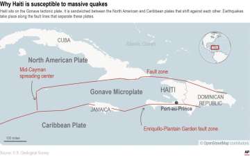
Also, the Earth's crust is made up of tectonic plates that move. Haiti sits near the intersection of two of them -- the North American plate and Caribbean plate.
As per news agency AP, multiple fault lines between those plates cut through or near the island of Hispaniola, which Haiti shares with the Dominican Republic. And, not all of those fault lines behave the same way.
The 7.2-magnitude earthquake likely occurred along the Enriquillo-Plantain Garden fault zone, which cuts across Haiti’s southwestern Tiburon Peninsula. It’s the same fault zone along which the devastating 2010 earthquake occurred. And it’s likely the source of three other big earthquakes in Haiti between 1751 and 1860, two of which destroyed Port-au-Prince.
READ MORE: Haiti Earthquake: Tensions over aid grow as death toll passes 2,000

