North Korea earthquake: South Korea claims it’s natural; USGS says can’t confirm
The quake was detected in an area around Kilju, in northeastern North Korea, and about 20 kilometers (12 miles) southeast of where the North conducted its sixth and most powerful nuclear test on Sept. 3.

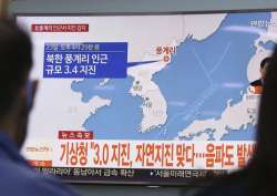
South Korea’s weather agency said a magnitude 3.0 earthquake was detected in North Korea on Saturday around where the country recently conducted a nuclear test, but it assessed the quake as natural. The quake was detected in an area around Kilju, in northeastern North Korea, and about 20 kilometers (12 miles) southeast of where the North conducted its sixth and most powerful nuclear test on Sept. 3, according to an official from Seoul’s Korea Meteorological Administration.
China’s official Xinhua News Agency said earlier that the country’s seismic service detected a magnitude 3.4 quake in North Korea and saw the likely cause as an explosion. But the official from the South Korean agency said the analysis of seismic waves and the lack of sound waves clearly showed that the quake wasn’t caused by an artificial explosion. She spoke on condition of anonymity, citing office rules.
North Korea’s weakest nuclear test, its first one, conducted in 2006, generated a magnitude 4.3 quake. The USGS measured this month’s nuclear test at magnitude 6.3.
North Korea has been maintaining a torrid pace in nuclear and weapons tests as it accelerates its pursuit of nuclear weapons that could viably target the United States and its allies in Asia. North Korea said its recent nuclear test was a detonation of a thermonuclear weapon built for its developmental intercontinental ballistic missiles. In two July flight tests, those missiles showed potential capability to reach deep into the U.S. mainland when perfected.
Can't confirm if quake natural or man-made: USGS
Meanwhile, the US Geological Survey said on that it could not conclusively confirm whether an earthquake detected in North Korea was man-made or natural. USGS put the epicentre of the quake 22 km (14 miles) east-northeast of Sungjibaegam, North Korea, near the country's main nuclear test site.
"The depth is poorly constrained and has been held to 5 km by the seismologist," USGS said. "The Air Force Technical Applications Center (AFTAC) is the sole organization in the US federal government whose mission is to detect and report technical data from foreign nuclear explosions."