Chamoli Glacier Break: SDRF team conducts survey of lake formed near Rishiganga river | Watch
Days after the Chamoli glacier break in Uttarakhand following which a lake had formed near Raini village, posing another danger, the State Disaster Response Force (SDRF) team on Saturday that reached the lake formation site, reviewed the situation.

Days after the Chamoli glacier break in Uttarakhand following which a lake had formed near Raini village, posing another danger, the State Disaster Response Force (SDRF) team on Saturday that reached the lake formation site, reviewed the situation.
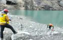
State Disaster Response Force team reviewed the situation at the lake that has been formed upstream of near Raini village, near Tapovan, earlier today.
Speaking after SDRF team reviewed the situation, State DGP Ashok Kumar said, "Water is continuously discharging from the lake, it's not in danger zone."
An 8-member team of the SDRF conducted a survey of a lake in the catchment area of the turbulent Rishiganga river which had caused a deluge in Uttarakhand's Chamoli district on February 7.
The team headed by SDRF Commandant Navneet Bhullar returned to Reni village in Chamoli district on Saturday evening after collecting samples from the lake besides filming videos of the area.
"We will send these samples and videos to the police headquarters in Dehradun for further action," said Bhullar.
ALSO READ | Tapovan tunnel rescue: Rescuers shift strategy to locate trapped workers
The SDRF team, which began its trek on Friday morning, took nearly 13-14 hours to reach the lake where they set up a temporary camp on Friday evening.
Significantly, there is a considerable discharge from the lake also, Bhullar said. However, he refused to comment further on the discharge issue saying it is up to the scientists to take a note of it.
"We have also found a proper route to the lake which may help in case of any emergency in the future," Bhullar said.
After fears expressed by some villagers, the Uttarakhand government on Friday had sounded an alert after satellite images spotted the formation of a lake in the catchment area of the Rishiganga river.
"We have to remain alert as satellite pictures show the formation of a 400m lake at Rishiganga," Chief Minister Trivendra Singh Rawat had stated.
Top government officials said that people have been asked not to go near the Rishiganga river and take all precautions.
The government has also asked scientists of the Wadia Institute of Himalayan Geology and the Geological Survey of India to depute teams to the Rishiganga valley to prepare a detailed report on the lake formation.
Reports pouring in from different areas of Chamoli district said the flow of Rishiganga abruptly increased many times since Thursday afternoon which forced the authorities to suspend the search operation inside the disaster-hit tunnel of NTPC's 520 MW Tapovan-Vishnugad hydel project for a couple of times.
Rishiganga is a tributary of Dhauliganga river on which the Tapovan project is being built. Over 200 persons went missing after the Sunday morning deluge that had hit two hydel projects in Chamoli district.
ALSO READ | Uttarakhand: Geologist warns of impending danger after lake formation at Rishiganga river path