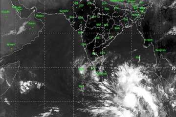
Cyclonic Storm ‘Fani’, which has been forming in south-east Bay of Bengal and the adjoining Indian Ocean, is very likely to intensify into a severe cyclonic storm during next 12 hours. It is expected to further intensify into a very severe cyclonic storm by tomorrow.
The Indian Meteorological department, in a press release said, "Cyclone Fani is very likely to intensify into a severe cyclonic storm during next 12 hours and into a very severe cyclonic storm during subsequent 24 hours."
It is very likely to move northwestwards till 1st May and thereafter recurve northeastwards gradually.
The weather department said it was found laying centred at 05:30 hrs over southeast Bay of Bengal and neighbourhood, about 745 km east-southeast of Trincomalee (Sri Lanka), 1050 km southeast of Chennai (Tamil Nadu) and 1230 km south-southeast of Machilipatnam (Andhra Pradesh).
Meanwhile, the Indian Meteorological Department (IMD) forecast light to moderate rainfall at many places with heavy falls at isolated places as very likely over Kerala on April 29 and 30.
It forecast light to moderate rainfall at few places over north coastal Tamil Nadu and coastal Andhra Pradesh on April 30 and May 1.
Besides squally winds that were very likely to become gale gusting up to a maximum of 145 kmph in the next two days in the Equatorial Indian Ocean and adjoining southwest Bay of Bengal, the sea condition was also rough to very rough in these areas, it said.
IMD advised fishermen not to venture into deep sea areas of Sri Lanka, Puducherry, Tamil Nadu and south Andhra Pradesh coasts between April 27 and May 1.
Those who are out in deep sea areas were advised to return to the coast by April 28, it added.
Latest India News
